
Interurban / Press
SteamMacWindowsNot launched
Press kit
Everything below is checkable. Where a figure is a count of something in the repository, the file it came from is named; where it is a published statistic, the dataset is named. If something here is wrong, it is a bug and we would like to know — write to press@playinterurban.com.
Description, three lengths
One line
Interurban is a transit planning simulation on 79 real metros — 54 in the United States, 25 in Europe, Asia and South America — built on open data and a four-step travel demand model that shows its work.
One paragraph
Interurban is a transit planning simulation in which you take office in one of 79 metropolitan areas (54 US, 25 in Europe, Asia and South America), pick a decade between 1920 and 2040, and build a network. US packs are not invented: every census tract carries its real 2020 population, its real jobs by workplace and its real median household income, and work trips are seeded from the observed LEHD LODES home-to-work commute matrix rather than synthesised from distance. International packs use OSM land-use zones, agency GTFS and a sourced population series; their jobs and commute flows are derived and labelled as such. Ridership is computed by a four-step travel demand model of the kind metropolitan planning organisations use — trip generation, pivot-point gravity distribution, nested-logit mode choice and frequency-based transit assignment, iterated to equilibrium. Cost overruns are drawn from the distribution Bent Flyvbjerg's work on large infrastructure describes. The model's coefficients, its sources and its seven named limitations are published in full.
Three paragraphs
Use the paragraph above, then:
An era in Interurban is not a vehicle catalogue. Each of the eight decades
moves nine independent levers: metro population, how centralised it is, cars
per household, real construction cost, land acquisition friction, the fare,
the share of operating cost somebody else pays, the federal capital match, and
what technology exists. In 1920 transit was a business expected to turn a
profit and there was no federal transit money at all; by 2025 roughly seven of
every ten operating dollars are somebody else's political decision. Playing
1920 and playing 2025 are not the same activity.
The name is the premise. The interurbans were America's first regional rail
network and briefly the largest electric railway system ever built —
15,580 miles across forty states at their 1916 peak, the only serious
competitor the steam railroads had before the car. They were pulled up almost
as fast as they went in, at roughly 650 miles a year through the 1930s, leaving
2,680 miles by 1943 and 1,519 by 1950. Modern light rail is their direct
descendant. Every American metro in this game is shaped by a network somebody
already built and somebody else removed, and the player is the next person to
try.
Fact sheet
| Item | Value | Where it comes from |
|---|---|---|
| Title | Interurban | Use the full string “Interurban — a transit planning simulation” on first mention; the bare word is a dictionary word. |
| Genre | Simulation / strategy / management | |
| Platform | Steam, macOS, Windows | No browser edition. The binary is the licence. Full $25 everywhere. 10% of every sale goes to pro-urban organisations; buy Mac/Windows direct and an extra 30% (Valve's Steam cut) goes with it. Free is the Steam demo or Interurban Free. |
| Status | Not launched. No store page, no reviews, no players. | |
| Price | Free edition free; full $25 once. 10% of every sale donated; 40% of a direct one | src/engine/edition.ts |
| Licence | MIT | LICENSE |
| Metros | 79 | 54 US Census 2020 + 25 Europe/Asia/South America OSM/GTFS — public/cities/index.json |
| Decades playable | 8 | 1920, 1950, 1960, 1975, 1992, 2010, 2025, 2040 — src/engine/eras.ts |
| Modes | 7 | Metro, commuter rail, light rail, streetcar, BRT, local bus, ferry — constants.ts |
| Events | 124 | 19 fiscal, 23 political, 23 operational, 15 social, 25 exogenous, 19 opportunity — events.ts |
| Time periods modelled | 6 | AM peak, midday, PM peak, evening, night, weekend — constants.ts |
| Progression ranks | 12 | Twelve railway jobs, section hand to president, each with a checkable source — ranks.ts |
| Victory conditions | 6 | Computed per city from its own starting position — victory.ts |
| Free edition | One metro and one mandate a week, from thirteen metros, 2025, five years | The complete simulation on this week’s assignment — edition.ts |
| AI disclosure | Built with AI assistance (Claude) | Stated in README.md unprompted |
The data
All free, permissive, no API key. Verified 28 September 2026.
- Census TIGERweb — tract boundaries, centroids, land area, hydrography, roads
- Census 2020 PL94-171 — population, population 18 and over, occupied households
- ACS 2018–2022 5-year, B19013 — median household income; suppressed tracts are recorded as unknown, never estimated
- LEHD LODES8 2022 — jobs by workplace and sector, workers by residence, and observed home-to-work commute flows
- FHWA HPMS 2020 — traffic counts and lane counts
- Agency GTFS feeds — real transit lines, stations and official line colours, with real opening years
- OpenStreetMap (ODbL) — land use, water and roads for the 25 international playable cores
- UN World Urbanization Prospects 2018 File 22 — agglomeration population 1950–2020 for international packs, scaled to the OSM core
40 of the 79 metros seed playable rail (metro, light rail, commuter, tram, BRT or ferry) already on the map: sixteen of the 54 US metros, and twenty-four of the 25 international metros. Local bus is drawn and stays decoration. The other 39 start with nothing, which is also true of them. Where the pack has rail, that network runs on day one — trains, boardings, operating cost — and the win conditions are set from those existing stats. Where an opening year is not documented, the line is absent from earlier eras rather than given a guessed date.
Counted from public/cities/index.json on 8 October 2026.
The validation, if you want a number to quote
| Network built | Modelled weekday journeys | Real system |
|---|---|---|
| One metro line, 16 stations | 27,500 | METRO Blue Line, ~25–30,000 |
| Three rail lines, 50 stations | 64,600 | Metro Transit rail, ~60–70,000 |
| Trip generation | 3.94 / person / day | US household travel surveys, 3.5–4.5 |
If you quote those, two caveats belong with them: station spacing changes the answer by an order of magnitude, and regional mode share comes out below the real system's because a test network is sparser than an agency running a hundred bus routes.
Assets
- The lockup (SVG, square) — five transit-map ribbons with white station dots converging under the INTERURBAN pill. This is the mark in the header, the footer, and the site icon. Also on the night ground, and as raster: logo.jpg (2048×2048), logo-dark.jpg.
- The wide lockup (SVG, 2:1) and logo-wide.jpg (2400×1200) — the social card only, where a 2:1 frame is required.
- The mark (SVG, no text, transparent) and logo-icon.jpg (1024×1024) — the five-ribbon knot alone, for icons.
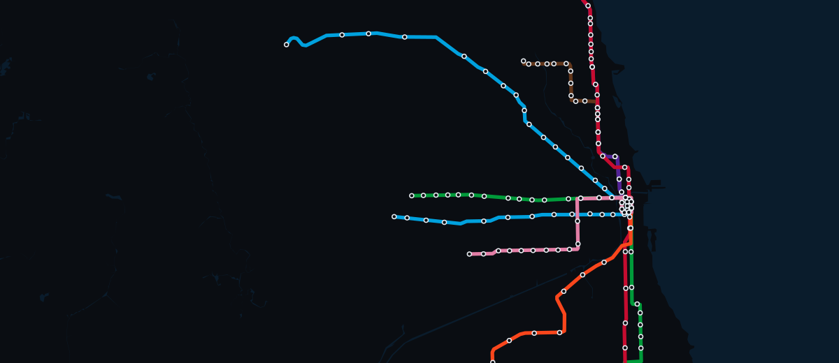
- The Chicago ‘L’ as the game draws it (SVG, 1200×520) — eight lines in the CTA's own published colours, 185 stations, over Lake Michigan.







Typefaces: Barlow Condensed (display and signage), Inter (interface), IBM Plex Mono (every figure, always tabular). Palette: ground #0E1116, panel #12171F, rule #242C38, ink #E8ECF1, accent #5FA8E8, good #4FBF87, warn #E0A63C, critical #E2685E.
Things this page will not claim
Because they are not true, and a press kit that inflates them makes every other number on it worthless:
- There are no review scores. The game has not launched.
- There are no player numbers, wishlists or downloads.
- There are no press quotes, and the slot for them on this site is deliberately empty rather than filled with something borrowed.
- There is a launch window, not a release date: late November 2026. The exact day goes to the mailing list first. The roadmap dates what is known and says “not dated” where it is not.
- Station upgrades and derived district identity ship in the interface — the station card and the land-use ledger. Do not write that they are engine-only.
Quotations
There are none. The site carries no press quotes and no review excerpts.
The 1,375 Steam reviews of comparable titles in research/data/
informed the design brief and are not quoted on the pages.